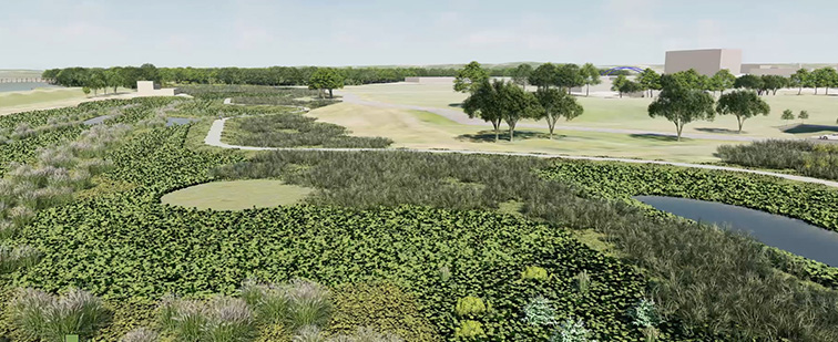
Creating the Gray’s Wetland Basin
One of the largest features of the Gray’s Station community is one that comes pretty naturally. Via the City of Des Moines, RDG Planning & Design (RDG) and Civil Design Advantage (CDA), three smaller basins are being combined into a single, larger wetland basin system which will better filter water that flows from the north to south in downtown Des Moines. From restoring native plants to improving the quality of water in the system, this basin will provide an educational and habitat unforeseen in the downtown corridor.
This wetland basin is located along the southern portion of Gray’s Station and just north of the Raccoon River levee. The basin itself will be able to serve a watershed for 390 acres of land, spanning from Ingersoll Avenue, through the Western Gateway neighborhood as well as Gray’s Station – covering much of the water runoff from the downtown core. The wetland basin system will also provide flood storage when extreme rainfall events occur.
The basin aims to boost environmental conservation efforts – including improving water quality – for more than 200 acres. Inside the basin, industry professionals have designed the basin with micro-topography. This creates a series of shallow and deep areas, forcing stormwater to pass through a “maze” system before reaching a pump station then releasing into the Raccoon River to the south.
Native plants & species
When the water enters the established wetland basin system and enters into the various levels of the basin, a natural-based filtration system will get to work. Native wetland plants will be established through seeding as well as plugged and plotted plants along the banks, water’s edge and throughout the basin’s bottom. The shallow efforts will be visible to the public along the edge, as various reeds and wetland grasses poke through the water’s surface.
Below the surface, natural vegetation like lake sedge and bulrush varieties will grow. Deep-water zones are included throughout this basin system to provide open water – not just for looks – but in order to allow for a fish population to survive and thrive.
In two years’ time, the wetland basin system south of Gray’s Station will transform from a barren detention-pond to a fertile, wetland system with visible growth and habitation aimed at enhancing sustainable, environmental conservation efforts.
Basin Opportunities
There will be endless opportunities to take advantage of while visiting the wetland basin system located near Gray’s Station. Aside from being a peaceful getaway from the hustle and bustle of the city, the overall design from CDA, RDG and the city incorporates entry points to the wetland features throughout the system. This includes small overlook points to forebays, potential seating along various higher points of the system as well as educational opportunities for nearby school systems.
The Gray’s Station trail that winds its’ way along the basin will also be heavily traveled by bikers, runners and everyday trail-users. The trail, which connects to the downtown trails to the east, will be an easier and quicker access point to connect to the Gray’s Station bridge, to Gray’s Lake, Water Works Park and beyond.